Arctic sea shipping: Emissions matter more than you might think
Blog
What is “Arctic shipping,” anyway?
The recent U.S. Supreme Court decision in Environmental Protection Agency v. EME Homer City Generation, upholding the EPA’s authority to regulate cross-boundary pollution from power plants, got me thinking about other instances of air pollution crossing boundaries – specifically in the Arctic, where the problem is complicated by the fact that there’s not even general agreement on where the supposed “boundary” should be drawn.
The issue before the Supreme Court was whether EPA could regulate emissions from power plants in states that “contribute significantly” to air problems in other states. This finding is based on the Good Neighbor provision (section 110(a)(2)(D)(i)(I)) of the Clean Air Act and gives EPA the authority to regulate interstate pollution that interferes with the ability to achieve attainment of national air quality standards, which protect public heath.
The circumstances of this case remind me of the 1930’s Trail Smelter dispute between the United States and Canada over sulfur dioxide emissions from a smelter processing lead and zinc in Trail, British Colombia, that were impacting agricultural lands in Washington State. After long and complicated negotiations produced no satisfactory outcome, the dispute eventually wound up before an arbitral tribunal. The tribunal’s decision [.pdf] (Arbitral Trib., 3 U.N. Rep. Int’l Arb. Awards 1905 (1941)) held that the duty to protect other states against harmful acts by individuals from within its jurisdiction at all times is the responsibility of the state.
The cornerstone premise of both decisions is that pollution does not necessarily stay in one place. It travels far and can impact people and ecosystems with no link to its origin. These cases involved crossing boundaries where the direct impact is on both sovereign land and its citizens. This presents a bit of a complication when discussing the high seas or areas of sparse population, like the Arctic.
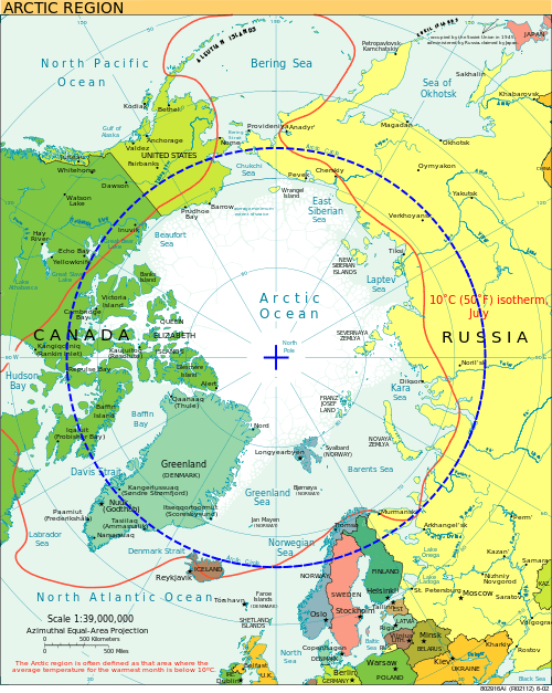
The Arctic is defined in a number of ways: 66° 32”N is the Arctic Circle; 60°N is often used in literature; the U.S. includes the Bering Sea in its definition (down to the Aleutian Islands); and other international definitions are more complicated and result in wiggly lines around the Arctic area (based on tree lines and isotherms).
Technically, international maritime laws protect the Arctic. The International Convention for the Prevention of Pollution from Ships (MARPOL) holds ships accountable for their emissions and requires that their flag registry enforce the laws. The difficulty lies in determining the point, line, or latitude at which emissions from ships begin to have an impact on the Arctic, and thus where a regulatory framework designed to protect the Arctic begins.
Recently, a number of reports and strategies were released from various US agencies and departments discussing plans and to-do lists for improving aspects of Arctic policy. These range from better oil-spill response to infrastructure needs (both physical, like buoys, and informational, like charts), security issues, ecosystem protection, and increased climate and weather modeling and research. There is also an ongoing international discussion about codes for Arctic vessels and whether air emissions can or should be included. These plans largely use one of the accepted definitions of Arctic. But as the Supreme Court case and the Trail smelter decision show, a line on the map is not sufficient to define an area impacted by air emissions. Perhaps a discussion of what it means to impact the Arctic is needed.
When considering the impact of emissions from ships, we know that only about 4% of the black carbon in the Arctic comes from ships operating within the Arctic. We also know that areas like the Bering Strait and Greenland have higher rates of deposition (5%) that are expected to increase (10–15%) in the coming decades. We also know that about 33% of emissions from vessels occur north of 40°N, an area of ocean that includes routes between the US and Europe as well as Asia and the US via the Great Circle Route, which passes between the Aleutian Islands. Although the Arctic may see only a few hundred or fewer large vessel transits each year, the Great Circle Route sees approximately 3,100 annually.
Although the Aleutian Islands are included in the US definition of the Arctic, they are located between 51°N and 55°N, well below the Arctic as defined by 60° N latitude, and certainly below the Arctic Circle. However, when considering management of Arctic regions and ecosystems, ignoring the potential contribution of emissions to air quality and ecosystem health (deposition of black carbon, acid rain from sulfur emissions, increased ozone from nitrogen emissions) because they are outside a designated boundary may be a fundamental mistake.
With the expansion of shipping into and sometimes through the Arctic, perhaps it is time to expand baseline definitions and assumptions, to adopt a more holistic approach for managing pollution and emissions in Arctic and near-Arctic environments. Limiting analysis to lines on a map is not only contrary to the idea of integrated management; it also rubs up against historic domestic and international legal cases.