The voyage of the Crystal Serenity and the risks of Arctic shipping
Blog
In the land of the midnight sun, Arctic shipping is on the rise
The luxury cruise ship Crystal Serenity offers many excursions on its unprecedented 32-day voyage through the icy waters of the Northwest Passage. One of them was a recent visit to Shishmaref, Alaska, for a “study in global warming.”
Shishmaref is the 580-resident Inupiat village that made the news this month when residents voted to relocate. Their small coastal island is under threat of serious erosion from rising sea levels, one symptom of a warming Arctic.
The voyage of the Crystal Serenity is made possible by the catastrophic warming of the Arctic. Some critics have denounced it as “extinction tourism.” The cruise, with 1,725 passengers and crew, is emblematic of a surge in Arctic ship traffic whose effects may worsen climate change in the delicate, thawing region. Operators of the ship are already planning a repeat voyage at the same time next year.
As the Arctic clears of its summer sea ice, we expect far more traffic in these remote northern waters. In the U.S. Arctic alone, the ICCT projects that shipping will increase by at least 75% from 2013 to 2025. Depending on changes in the global economy, the performance of the newly expanded Panama Canal, and fluctuations in seasonal sea ice, the increase may grow to 500%. Other researchers estimate that overall shipping activity in the whole of the Arctic will climb by more than 50% between 2012 and 2050.
Whatever the rise in Arctic vessel traffic, there will be far-reaching economic, environmental, and social implications. As larger cargo ships enter Arctic shipping, a 50% increase in traffic may actually result in as much as 120% more in carbon dioxide and black carbon emissions. And as we mentioned in our earlier post on the voyage, more traffic means more risks for heavy fuel oil spills as well as dumping of untreated sewage, graywater, and oily bilge water.
Arctic transport is attractive because it offers shorter routes, resulting in time and cost savings. For instance, China has recently encouraged ships flying its flag to follow routes through the Arctic instead of the longer, conventional routes to places like Europe and the North American East Coast. As shown in our map below, the distance between Shanghai and New York City is about 30% shorter through the Northwest Passage than through the Suez Canal.
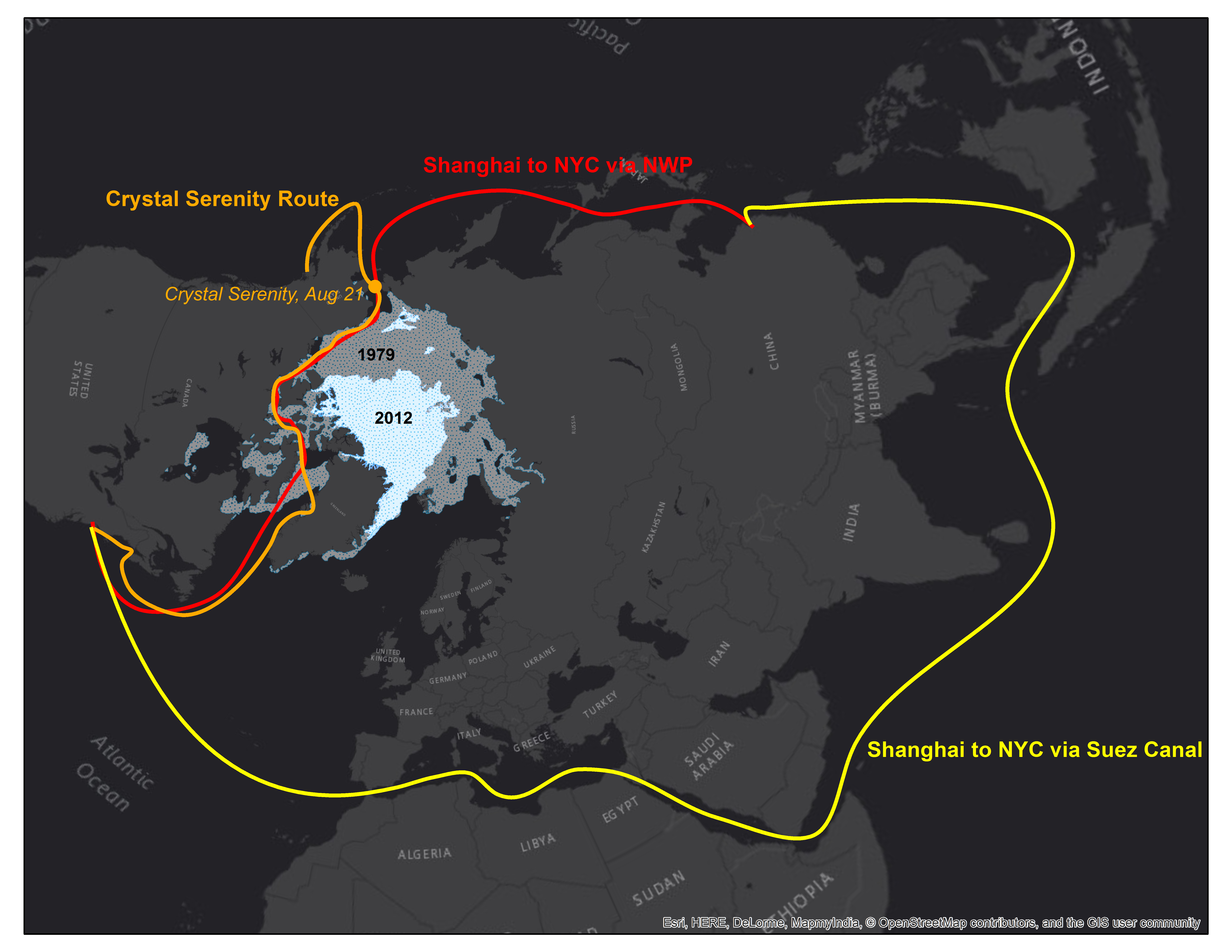
The route from Shanghai to New York City via the Northwest Passage (red) is about 30% shorter than the traditional route through the Suez Canal (yellow). The Crystal Serenity’s route (orange) is made possible by dwindling Arctic sea ice (compare 1979 with 2012’s minimum).
It’s true that shorter distances mean less fuel burn and therefore lower emissions on a global scale. But it’s not only how much is emitted, but where. Black carbon emissions, for example, turn into ugly black deposits on ice and rapidly speed the melting of already threatened ice masses.
This endangers not only the environment, but also the lifeblood of many Arctic communities whose food security depends on a healthy marine environment, like Shishmaref. At the International Maritime Organization’s next Marine Environment Protection Committee meeting in October in London, Pacific Environment, Friends of the Earth, and the World Wildlife Fund will sponsor a presentation from indigenous peoples called “Arctic Voices.” The event will showcase the importance of the Arctic environment to their survival and culture.
How can we measure the effects of Arctic shipping activity? In recent years, satellite coverage of ship activity in the Arctic has improved dramatically. While in transit, ships use Automatic Identification Systems (AIS) to emit signals on their location, speed, and direction to satellites. AIS data are the key to estimating and tracking ship emissions over time.
The ICCT recently acquired more than 2 billion satellite AIS data points covering the years 2013, 2014, and 2015. Of these, about 30 million cover ships in the Arctic. By marrying these data with specific vessel attributes, such as engine power and ship design speed, we can estimate a ship’s fuel consumption and resulting emissions.
The ICCT Marine Team will use the AIS data as the foundation for refined inventories of global and regional ship emissions. In October, we’ll release an Arctic ship emissions inventory for 2015, with projections for 2020 and 2025.
As we gain a more complete understanding of ship activity using the satellite AIS data, we can better estimate the environmental and economic effects of international shipping, especially in fragile environments such as the Arctic. In our next blog post, we’ll discuss the “most significant threat from ships to the Arctic marine environment”: heavy fuel oil. Meanwhile, the Crystal Serenity continues her journey north.